Best Road Trips In India – Manali to Leh Highway
Hi guys, road trips are best if you are on a scenic route amongst your friends or family members. today we are talking about best and most scenic in India – Manali – Leh Highway. This route is only open in the summers season of India i.e. between mid May to mid October.
Length of highway:
The total length of the highway is about 490 km (300 mi). The distance in Himachal Pradesh state between Manali and Sarchu is 230 km (140 mi) and the distance in Ladakh region from Sarchu to Leh is 260 km (160 mi).
Route:
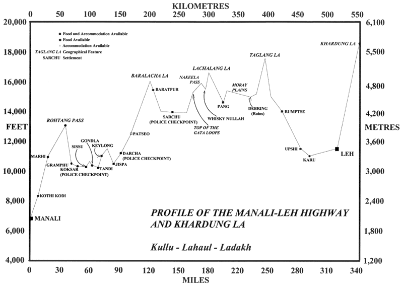
Manali – Rohtang La – Gramphu – Kokhsar – Tandi – Keylong – Jispa – Darcha – Zingzingbar – Baralacha La – Bharatpur – Sarchu (state border) – Gata Loops – Nakee La – Lachulung La – Pang – More Plains – Tanglang La – Gya – Upshi – Karu – Leh

Destinations you would cover:
- Manali (altitude 1,950 m (6,400 ft)) to Marhi at 3,300 m (10,800 ft) elevation 33 km (21 mi). It is a steady climb.
- Marhi to Rohtang Pass at 3,980 m (13,060 ft) elevation 18 km (11 mi). It is a steady climb.
- Rohtang to Gramphu at 3,200 m (10,500 ft) elevation 19 km (12 mi). It is a steady descent. Turn left (towards west) at Gramphu on the highway along Chandra river. The right turn (towards east) at Gramphu leads to Spiti valley and Batal, Kunzum La and Kaza on a road along Chandra river that is paved for some distance and then unpaved.
- Gramphu to Kokhsar, the first village north of Rohtang Pass 6 km (3.7 mi). Foreign nationals have to show their passports with valid visa at the police check post here. (Anyone can visit Leh freely. However, special permission is needed to visit some restricted areas beyond Leh. This permit can be obtained at Leh.)
- Kokhsar to Sissu at 3,130 m (10,270 ft) elevation 25 km (16 mi). There is a helipad at Sissu. The highway runs along left (south) bank of Chandra River.
- Sissu to Tandi at 2,570 m (8,430 ft) elevation 8 km (5.0 mi). Tandi is situated at the bottom of the river valley at the confluence of the Chandra river and the Bhaga river (flowing down from north) which merge to form the Chandra-Bhaga river (that later becomes known as Chenab downstream in Jammu and Kashmir). Cross the Bhaga river over the bridge towards the right, take the right turn at the fork and the road again starts climbing.
- Tandi to Keylong at 3,080 m (10,100 ft) elevation 9 km (5.6 mi).
- Keylong to Jispa at 3,310 m (10,860 ft) elevation 22 km (14 mi).
- Jispa to Darcha at 3,360 m (11,020 ft) elevation 6 km (3.7 mi). All tourists have to register at the police check post here.
- Darcha to Zingzingbar 4,270 m (14,010 ft) elevation 26 km (16 mi). The steep ascent to Baralacha La starts at Zingzingbar.
- Zingzingbar to Baralacha La pass at 5,030 m (16,500 ft) elevation 18 km (11 mi). It is a steady climb. (Both the Bhaga river and the Chandra river originate from melting snow at opposite sides of Baralacha La, the former flowing southwest and the latter flowing first southeast and then northwest to merge at Tandi.)
- Baralacha La to Bharatpur 2 km (1.2 mi). It is a steady descent.
- Bharatpur to Sarchu at 4,300 m (14,100 ft) elevation 38 km (24 mi). Sarchu is a military base and has a police check post. Register at the police check post here. (Himachal Pradesh state ends here. Ladakh region of Jammu and Kashmir state starts here.)
- Sarchu to Pang 4,600 m (15,100 ft) elevation 80 km (50 mi) climbing 500 m through the Gata loops (22 hairpin bends) at 4,190 m (13,750 ft) elevation and traversing through Nakee La pass at 4,739 m (15,547 ft) and Lachulung La pass at 5,065 m (16,616 ft) elevations. Register at the check post at Pang.
- Pang to Tanglang La pass at 5,328 metres (17,480 ft) elevation, 69 km (43 mi) through a 4,700 m (15,400 ft) plateau called More plains or Morey plains.
- Tanglang La pass to Upshi 60 km (37 mi). Upshi has a Customs and Excise taxation check post before crossing the river. Stop here for checking of vehicles. Then cross Indus river to reach Upshi village on the right bank (north) of the river. An ancient trading road (right turn while coming from Manali and going to Leh) heads to the east from Upshi towards Tibet. There is a helipad on this road.
- Upshi to Karu 16 km (9.9 mi) After crossing Indus river, the highway is on the right bank (north) of the river from Upshi to Leh. Turn left at Upshi for Karu. Do not take the right turn that leads to the east towards Tibet.
- Karu to Leh at 3,500 metres (11,483 ft) elevation, 35 km (22 mi) Continue on the highway towards Leh. Do not take the right turn just before Karu that leads to Shyok.
The distance from Lachalang La pass to the Tanglang La pass is 87 km (54 mi) via Pang.
You can view below a 360 degree view of all the mountain passes on the Manali – Leh Highway
Source for Destinations covered – Leh Manali Highway
Please feel free to share your feedback and suggestions in the comments section below.
Follow us for motorsports updates on our Facebook Page, Twitter Handle and Instagram feed

